| Latitude 39° 17´N |
Longitude 86° 46´W |
Elevation 168 meters |
 COOP Midwest |
 Indiana |
Help Main |
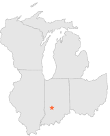
| 0 mi | N : | SPENCER WATER WORKS, IN |
| 13 mi | SE : | BLOOMINGTON 5 SW, IN |
| 14 mi | NW : | BOWLING GREEN 3 NE, IN |
| 16 mi | ESE : | BLOOMINGTON INDIANA UNIV, IN |
| 16 mi | SW : | WORTHINGTON, IN |
| 18 mi | NNW : | CLOVERDALE 4 WNW, IN |
| 19 mi | NNE : | EMINENCE, IN |
| 19 mi | ENE : | MARTINSVILLE 2 SW, IN |
| 19 mi | E : | MARTINSVILLE STATE FOREST, IN |
| 19 mi | SSW : | ELLISTON, IN |