| Latitude 43° 27´N |
Longitude 83° 24´W |
Elevation 204 meters |
 COOP Midwest |
 Michigan |
Help Main |
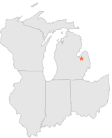
| 3 mi | N : | CARO S C S, MI |
| 15 mi | NE : | CASS CITY 1 SSW, MI |
| 16 mi | NNW : | UNIONVILLE, MI |
| 16 mi | NW : | AKRON 7 NW, MI |
| 17 mi | SSW : | MILLINGTON 3 SW, MI |
| 18 mi | S : | COLUMBIAVILLE 5 NE, MI |
| 18 mi | S : | LAPEER 4 SW, MI |
| 19 mi | N : | SEBEWAING WATERWORKS, MI |
| 20 mi | N : | SEBEWAING, MI |
| 25 mi | SE : | BURNSIDE 1 E, MI |