| Latitude 45° 33´N |
Longitude 94° 3´W |
Elevation 313 meters |
 COOP Northern Plains |
 Minnesota |
Help Main |
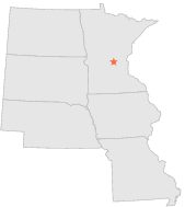
| 14 mi | E : | SANTIAGO 3 E, MN |
| 17 mi | W : | COLLEGEVILLE ST JOHN, MN |
| 25 mi | NW : | ROYALTON 5 W, MN |
| 25 mi | NE : | MILACA 1 ENE, MN |
| 26 mi | NNW : | BLANCHARD POWER STN, MN |
| 27 mi | SSE : | BUFFALO, MN |
| 28 mi | SE : | ELK RIVER, MN |
| 33 mi | SSW : | COKATO, MN |
| 33 mi | NNW : | LITTLE FALLS WATER WORKS, MN |
| 34 mi | NNW : | LITTLE FALLS 1 N, MN |