| Latitude 31° 43´N |
Longitude 110° 11´W |
Elevation 1174 meters |
 COOP Southwest |
 Arizona |
Help Main |
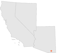
| 5 mi | E : | TOMBSTONE, AZ |
| 7 mi | NNW : | BENSON 6 SE, AZ |
| 8 mi | SSW : | SIERRA VISTA, AZ |
| 8 mi | NNW : | APACHE POWDER COMPANY, AZ |
| 8 mi | SW : | FORT HUACHUCA, AZ |
| 11 mi | NNW : | BENSON, AZ |
| 11 mi | NNW : | BENSON, AZ |
| 11 mi | S : | Y LIGHTNING RANCH, AZ |
| 12 mi | W : | ELGIN 5 N, AZ |
| 13 mi | S : | FLYING H RANCH, AZ |