| Latitude 38° 48´N |
Longitude 90° 34´W |
Elevation 166 meters |
 COOP Northern Plains |
 Missouri |
Help Main |
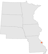
| 4 mi | ESE : | ST CHARLES, MO |
| 8 mi | SSE : | ST CHARLES 7 SSW, MO |
| 9 mi | SW : | WELDON SPRING, MO |
| 11 mi | ESE : | ST LOUIS LAMBERT INT'L ARPT, MO |
| 15 mi | NNW : | CAP AU GRIS L & D 25, MO |
| 17 mi | SE : | SAINT LOUIS WASHINGTON UNIV, MO |
| 18 mi | SSE : | VALLEY PARK, MO |
| 19 mi | SE : | WEBSTER GROVES, MO |
| 20 mi | SE : | ST LOUIS SCIENCE CTR, MO |
| 21 mi | ESE : | ST LOUIS ST LOUIS UNIV, MO |